20th April 2016
 |
The Department of Environment is implementing a four month Unmanned Aerial Systems (UAS) or 'drone' mapping and data management exercise that will show how drone technology can be used to support conservation efforts in Antigua and Barbuda and across the region.
Potential drone for conservation applications include: terrestrial and marine habitat mapping and vegetation health assessments using an infrared lens, high resolution elevation data for modelling watersheds and streams, post disaster (hurricane/flood) recovery efforts, monitoring and inspections in remote areas, sea turtle, seabirds and other wildlife monitoring, as well as various surveillance, enforcement and evidence gathering applications.
Drones can be used to collect large amounts of data at a fraction of traditional costs, helping decision-makers make informed decisions.
Under the Sustainable Financing & Management of Eastern Caribbean Marine Ecosystem Project funded by the GEF/World Bank and implemented by the Nature Conservancy, two 3DR Solo drones equipped with high resolution cameras and PiX4D mapping software were acquired for the Department of Environment.
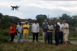
Last week, UAS mapping experts Dr. Steve Schill from The Nature Conservancy and Dr. George Raber of The University of Southern Mississippi provided a "training of the trainers" to seven persons from the Department of Environment, Surveys and Mapping Division, Fisheries Division, Development Control Authority, Environmental Awareness Group and the University of the West Indies (UWI) equipping participants with both skills in the operation of UAS 'drone' technologies and the application of innovative 3D mapping and monitoring methods to support conservation.
As part of this training exercise, three demonstration site missions were flown, at Cashew Hill to collect elevation data for ongoing flood mitigation and drainage works, at Johnsons Point for mangrove mapping and over Cades Bay reef. For the next few months, the Department of Environment will be working with Dr. Kimberly Baldwin of CERMES, UWI to build the Department's capacity in the use of the UAS, mapping methods and spatial data management of the Environmental Information Management and Advisory System (EIMAS) - the national repository for environmental data.
Dr. Baldwin will also be processing the demonstration sites aerials and analysing the spatial data collected during the training exercise. The Drone for Conservation Project is working with stakeholders to develop UAS protocols for the Department of Environment as well as provide recommendations for the development of a national UAS policy for Antigua and Barbuda. Lessons and knowledge will be documented and shared broadly among protected area manageres in the regions.
For More Information Contact:
Debbie Francis
Communications Officer
Tel: (268) 464-8026